

Comprehensive Surveying & GIS Data Solutions in Kenya.
Introduction to Our Surveying & GIS Expertise.
Surveying & GIS Data Solutions. At Ler Consult Ltd, we understand that precise geospatial data forms the backbone of successful land development and infrastructure projects. Our Surveying and GIS Division combines cutting-edge technology with professional expertise to deliver accurate, reliable, and actionable spatial solutions across Kenya. Whether you require land boundary demarcation, topographic mapping, or advanced geospatial analysis, our team of licensed surveyors and GIS specialists ensures compliance with Kenyan regulations while providing data-driven insights for informed decision-making.
Our Core Surveying & GIS Services.
1. Land Surveying Services.
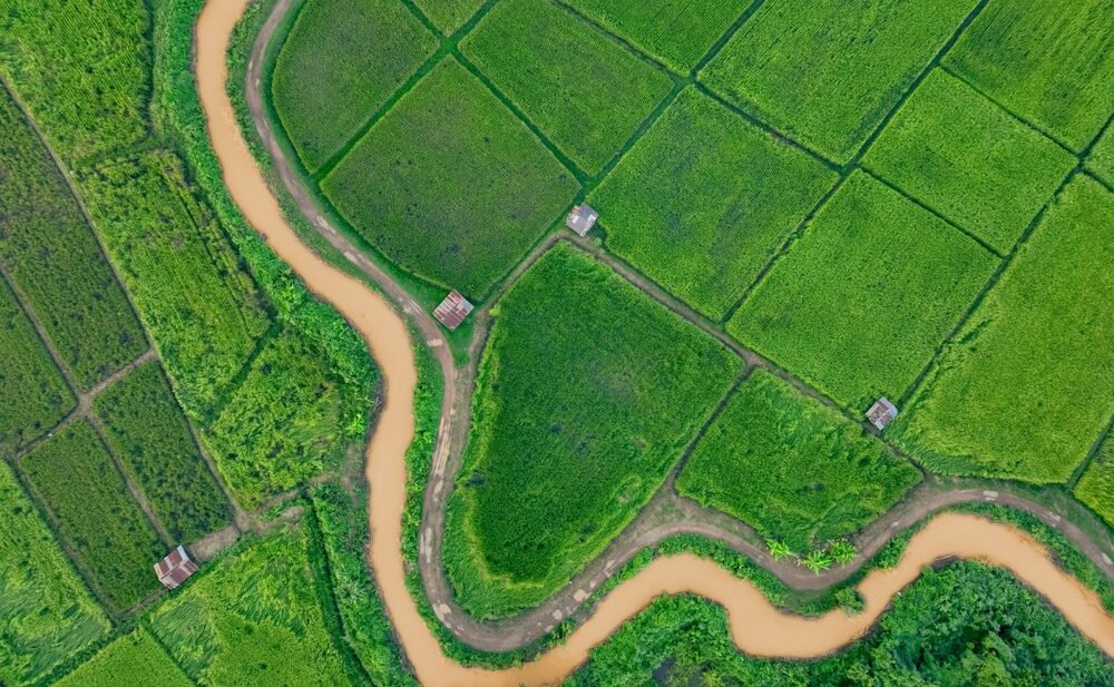
Surveying & GIS Data Solutions. We provide high-precision land surveys to support property development, legal documentation, and infrastructure planning.
✔ Cadastral Surveys – Our team conducts legally binding boundary surveys to establish accurate property lines, place beacons, and prepare documents for title processing with the Ministry of Lands. These surveys are essential for resolving land disputes and ensuring proper land ownership records.
✔ Topographic Surveys – We map terrain contours, natural features, and man-made structures to support engineering designs, drainage planning, and construction projects. Our surveys help architects and developers optimize site layouts while minimizing environmental impact.
✔ Engineering Surveys – We provide precise alignment and elevation data for road construction, building foundations, and utility installations. Our surveys ensure projects are built according to design specifications with minimal errors.
✔ Subdivision Surveys – We assist landowners in legally partitioning property into smaller plots for sale or development. Our surveys comply with county government regulations, ensuring smooth approval processes.
2. GIS & Geospatial Data Solutions.
We transform raw spatial data into strategic insights for better planning and resource management.
✔ GIS Mapping & Spatial Analysis – Using ArcGIS, QGIS, and other advanced tools, we analyze land use patterns, infrastructure networks, and environmental factors. Our GIS services support urban planning, disaster risk assessment, and natural resource management.
✔ Remote Sensing & Drone Surveys – Our UAV (drone) technology captures high-resolution aerial imagery for large-scale mapping projects. This is ideal for mining sites, agricultural land assessments, and infrastructure monitoring.
✔ Land Information Systems (LIS) – We develop digital land records management systems for counties and institutions, improving transparency and efficiency in land administration.
✔ 3D Terrain Modeling – We create interactive 3D maps for urban development, flood modeling, and construction planning, helping stakeholders visualize projects before implementation.
3. Land Adjudication & Settlement Surveys.
We support government and community land programs with legally compliant surveys.
✔ Adjudication Surveys – We help communal land owners formalize their holdings through systematic demarcation and registration under the Community Land Act.
✔ Settlement Schemes Mapping – We assist in resettlement programs by mapping allocated parcels and ensuring proper documentation for beneficiaries.
✔ Land Dispute Resolution – Our accurate boundary surveys provide legal evidence to resolve conflicts over land ownership and usage rights.
4. Survey Data Processing & Cartography.
We convert field measurements into professional maps and digital reports.
✔ CAD & GIS-Compatible Outputs – We deliver data in formats compatible with AutoCAD, Civil 3D, and other engineering software for seamless project integration.
✔ Custom Thematic Maps – We design specialized maps for zoning, environmental studies, and infrastructure planning.
✔ Interactive Web Mapping Dashboards – Our online GIS platforms allow clients to access, analyze, and share spatial data in real time.
Why Choose Ler Consult for Surveying & GIS in Kenya?
Licensed & Accredited – Our surveyors are registered with the Surveyors Board of Kenya, guaranteeing compliance with the Survey Act (Cap 299).
Advanced Technology – We use RTK GPS, Total Stations, Drones, and LiDAR for sub-centimeter accuracy in measurements.
Fast & Efficient – Our streamlined workflows ensure quick turnaround times without compromising quality.
End-to-End Solutions – From field data collection to digital mapping and analysis, we handle every step of the process.
Regulatory Compliance – All our surveys meet NMA, county government, and international standards.
Our Recent Projects.
-
GIS-Based Land Use Plan for Nairobi County – Developed a digital zoning map to guide sustainable urban expansion.
-
Cadastral Survey for a 500-Acre Mixed-Use Development – Provided legally binding boundaries for a major real estate project in Mombasa.
-
Drone Topographic Mapping for a Highway Project – Delivered high-resolution terrain data for the construction of a new expressway.
-
Land Adjudication Survey in Laikipia – Assisted a community in formalizing land ownership under the Community Land Act.
Partner with Kenya’s Leading Geospatial Experts.
Whether you’re a real estate developer, government agency, or private investor, accurate surveying and GIS data are critical for project success. Ler Consult Ltd provides reliable, precise, and compliant geospatial solutions tailored to your needs.
Aligning with National Geospatial Trends.
Kenya’s geospatial sector is experiencing significant advancements, with trends such as AI-driven geospatial analysis, integration of IoT with GIS, and cloud-based GIS solutions shaping the future of urban planning and infrastructure development. LightBox
Moreover, initiatives like the Africa Geospatial Expo and Conference (AGE) provide platforms for professionals to exchange ideas and showcase innovations in the geospatial domain. age.orbital.co.ke+1age.orbital.co.ke+1
Ler Consult Ltd’s services are well-aligned with these national trends, ensuring that clients benefit from the latest advancements in geospatial technology.